
Flood room status

Flood Room Live is deactivated. For information on current river levels, flows and rainfall accumulations, please visit our Environmental Data Hub.
Weather forecasts and sites monitored
Published Wednesday, 30 April 2025
Situation
The Coromandel and Waihou Piako zones received some heavy rainfall overnight, with associated thunderstorms and heavy downpours, causing rivers across the eastern parts of the region to rise. Visit our Environmental Data Hub for the latest river level and rainfall accumulations.
Heavy rainfall and strong westerly winds associated with a low pressure system and will impact the region from Wednesday to Thursday. Additionally, for the eastern Coromandel Peninsula, the concurrence of high tide and swell is likely to cause some minor localised coastal impacts.
Please keep up to date with the latest forecasts as more Watches or Warnings are likely to be issued in the coming days.
MetService forecast
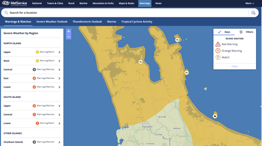
Strong Wind Watch
Area: Auckland, Great Barrier Island, Coromandel Peninsula, and Waikato north of Hamilton
Period: 5 hours from 7am Thursday to 12pm Thursday
Forecast: Westerly winds may approach severe gale in exposed places.
Moderate chance of upgrading to a Warning.
Heavy Rain Watch
Area: Bay of Plenty about and west of Opotiki (including Kaimai ranges and southern parts of the Coromandel Ranges in the Waikato region)
Period: 11 hours from 10am Wednesday to 9pm Wednesday
Forecast: Periods of heavy rain, and amounts may approach warning criteria. Thunderstorms possible.
Moderate chance of upgrading to a Warning.
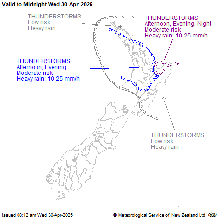
Thunderstorm outlook
The complex trough of low pressure affects northern and central New Zealand, bringing possible periods of heavy rainfall to parts of the region.
There is a moderate risk of thunderstorms this afternoon and evening for southwest Northland, Auckland (including Great Barrier Island), Waikato, Waitomo, the far north of Taranaki, Taumarunui, Taihape, Taupō, Coromandel Peninsula, Bay of Plenty. These thunderstorms may bring localised rainfall rates of 10 to 25 mm/h.
Moving into Thursday morning, for coastal parts of Waikato and Waitomo, there is a moderate risk of thunderstorms before dawn. These thunderstorms may bring localised rainfall rates of 10 to 25 mm/h. Additionally, there is a low risk of thunderstorms for the rest of the Waikato region.

What we are now doing
Our response staff continue to monitor weather forecasts and key sites across the region.
Likely/potential Impacts
Rivers and lakes
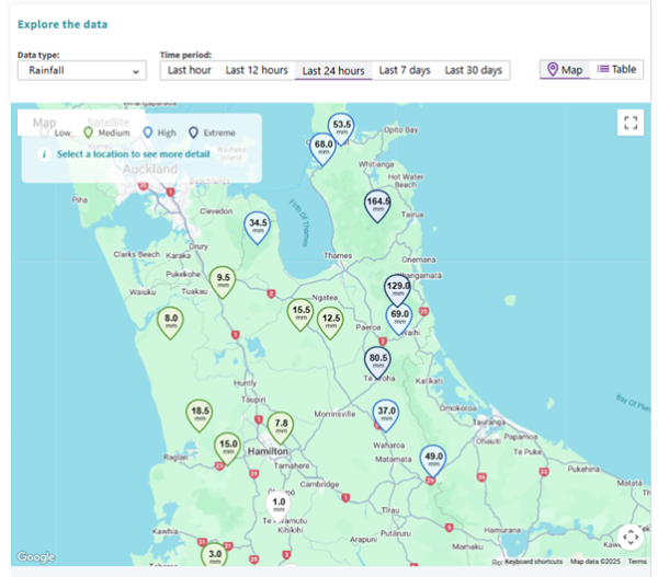
Even without prior watches or warnings in place for Tuesday night, Coromandel and Hauraki catchments received significant rainfall last night, including 160mm at Pinnacles, 130mm at Golden Cross, and 70mm at Queens Head rainfall gauges over the last 24 hours.
The Ohinemuri River level at Karangahake has just peaked and is expected to start falling shortly, along with other rivers in the area.
We are closely monitoring the Waihou River, which takes some time to respond. The Waihou River in Te Aroha is still rising. As the water moves downstream, the river will begin to peak in areas like Tirohia. Downstream of Paeroa, the Waihou River is influenced by coastal tides, so you can expect higher river levels during high tides.
However, with the possibility of thunderstorms throughout the day bringing potential heavy downpours, these may cause rivers to rise quickly again.
There is a possibility of localised river flooding in low lying areas, especially during high tides.
Wind
A strong wind watch is in force for eastern and northern parts of the region, with westerly winds that may approach severe gale in exposed places.
Please keep up to date with information from your local electricity provider for power outage extents and estimated restoration time, and for the latest roading conditions from your local council and NZ Transport Agency Waka Kotahi.
Coastal impacts
The current coastal conditions are unlikely to cause significant coastal inundation. For eastern Coromandel, the concurrence of high tide and swell is likely to cause some wave overtopping in low lying areas during high tides. Coastal erosion is possible over high tides, where water will likely reach the dune areas.
The coastal impacts are expected during high tide tonight and possibly tomorrow morning. The tide times for Whitianga are:
Wednesday 30/04/2025
• Low tide - 02:35 pm
• High tide - 8:57 pm
Thursday 01/05/2025
• Low tide - 03:09 am
• High tide - 09:13 am
• Low tide - 03:27 pm
• High tide - 09:50 pm
Land instability
As expected, several shallow landslides have occurred around the Coromandel Peninsula and impacted local roads.
While the main rainfall event may have passed it is important to be aware of a heightened landslide risk in coming days as soils are more saturated.
Central and southern areas of the Coromandel Peninsula have received the highest rainfall so the Tapu-Coroglen Road and State Highways 25 and 25A in particular will remain vulnerable for a time. Travellers using these routes should check the latest road conditions with Thames-Coromandel District Council and NZ Transport Agency Waka Kotahi.
Waikato Regional Council flood and drainage schemes
Local flood response staff are on standby monitoring the situation.
All flood and drainage schemes across the region are operating as they should.
Waikato Regional Council telemetry
All Waikato Regional Council telemetry is working. Visit our Environmental Data Hub for the latest river level and rainfall accumulations.
Next update
Flood Room Live will be updated by 1pm on Thursday, 1 May.


- Waikato Regional Council Facebook page (@WaikatoRegion)
- Waikato Regional Council Twitter (@ourwaikato)
- Waikato Region Civil Defence Facebook page (@WaikatoCivilDefence)
- Waikato Region Civil Defence Twitter (@CivilDefenceWKT)
- New Zealand Civil Defence Facebook page (@NZCivilDefence)
- National Emergency Management Agency Twitter (@NZcivildefence)